Catalogue Search | MBRL


Are you sure you want to remove the book from the shelf?

{{itemTitle}}
1,624
result(s) for
"Sharp, Iain"
Sort by:

Comparing MODIS and near-surface vegetation indexes for monitoring tropical dry forest phenology along a successional gradient using optical phenology towers
Tropical dry forests (TDFs) present strong seasonal greenness signals ideal for tracking phenology and primary productivity using remote sensing techniques. The tightly synchronized relationship these ecosystems have with water availability offer a valuable natural experiment for observing the complex interactions between the atmosphere and the biosphere in the tropics. To investigate how well the MODIS vegetation indices (normalized difference vegetation index (NDVI) and the enhanced vegetation index (EVI)) represented the phenology of different successional stages of naturally regenerating TDFs, within a widely conserved forest fragment in the semi-arid southeast of Brazil, we installed several canopy towers with radiometric sensors to produce high temporal resolution near-surface vegetation greenness indices. Direct comparison of several years of ground measurements with a combined Aqua/Terra 8 day satellite product showed similar broad temporal trends, but MODIS often suffered from cloud contamination during the onset of the growing season and occasionally during the peak growing season. The strength of the in-situ and MODIS linear relationship was greater for NDVI than for EVI across sites but varied with forest stand age. Furthermore, we describe the onset dates and duration of canopy development phases for three years of in-situ monitoring. A seasonality analysis revealed significant discrepancies between tower and MODIS phenology transitions dates, with up to five weeks differences in growing season length estimation. Our results indicate that 8 and 16 day MODIS satellite vegetation monitoring products are suitable for tracking general patterns of tropical dry forest phenology in this region but are not temporally sufficient to characterize inter-annual differences in phenology phase onset dates or changes in productivity due to mid-season droughts. Such rapid transitions in canopy greenness are important indicators of climate change sensitivity of these already endangered forest ecosystems and should be further monitored using both ground and satellite approaches.
Journal Article

Calibration of Co-Located Identical PAR Sensors Using Wireless Sensor Networks and Characterization of the In Situ fPAR Variability in a Tropical Dry Forest
The fraction of photosynthetic active radiation (fPAR) attempts to quantify the amount of enery that is absorbed by vegetation for use in photosynthesis. Despite the importance of fPAR, there has been little research into how fPAR may change with biome and latitude, or the extent and number of ground networks required to validate satellite products. This study provides the first attempt to quantify the variability and uncertainties related to in-situ 2-flux fPAR estimation within a tropical dry forest (TDF) via co-located sensors. Using the wireless sensor network (WSN) at the Santa Rosa National Park Environmental Monitoring Super Site (Guanacaste, Costa Rica), this study analyzes the 2-flux fPAR response to seasonal, environmental, and meteorological influences over a period of five years (2013–2017). Using statistical tests on the distribution of fPAR measurements throughout the days and seasons based on the sky condition, solar zenith angle, and wind-speed, we determine which conditions reduce variability, and their relative impact on in-situ fPAR estimation. Additionally, using a generalized linear mixed effects model, we determine the relative impact of the factors above, as well as soil moisture on the prediction of fPAR. Our findings suggest that broadleaf deciduous forests, diffuse light conditions, and low wind patterns reduce variability in fPAR, whereas higher winds and direct sunlight increase variability between co-located sensors. The co-located sensors used in this study were found to agree within uncertanties; however, this uncertainty is dominated by the sensor drift term, requiring routine recalibration of the sensor to remain within a defined criteria. We found that for the Apogee SQ-110 sensor using the manufacturer calibration, recalibration around every 4 years is needed to ensure that it remains within the 10% global climate observation system (GCOS) requirement. We finally also find that soil moisture is a significant predictor of the distribution and magnitude of fPAR, and particularly impacts the onset of senescence for TDFs.
Journal Article
Heaphy
Richly illustrated with Charles Heaphy's remarkable paintings and drawings as well as photographs and maps from the period, this engaging work tells the story of Heaphy's life and his art. A draughtsman, explorer, surveyor, gold agent, geologist, soldier, war hero, politician, land commissioner, and judge—even by the versatile standards of Victorian pioneers, Charles Heaphy had an unusually varied career. His biography tells as much about his own life as it does of the settlement of New Zealand. From his earliest surviving watercolor of bird life in 1839 to his last-known sketch, drawn on the back of an envelope in 1879, Charles Heaphy's art represents a remarkable visual diary of life as a settler in New Zealand.
eBook
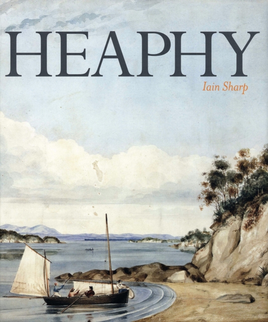
Heaphy
Richly illustrated with Charles Heaphy's remarkable paintings and drawings as well as photographs and maps from the period, this engaging work tells the story of Heaphy's life and his art. A draughtsman, explorer, surveyor, gold agent, geologist, soldier, war hero, politician, land commissioner, and judge-even by the versatile standards of Victorian pioneers, Charles Heaphy had an unusually varied career. His biography tells as much about his own life as it does of the settlement of New Zealand. From his earliest surviving watercolor of bird life in 1839 to his last-known sketch, drawn on the back of an envelope in 1879, Charles Heaphy's art represents a remarkable visual diary of lifenbsp;as anbsp;settler in New Zealand.
eBook

Heaphy: Artist, Explorer, Settler
Even by the versatile standards of Victorian pioneers, Charles Heaphy had an unusually varied career: as a draughtsman, explorer, surveyor, gold agent, geologist, soldier, war hero, politician, land commissioner and judge. Most importantly, however, for decades Heaphy painted and sketched what he saw. From his earliest surviving watercolour of birdlife in the Marlborough Sounds in August 1839 to his last known sketch, drawn on the back of an envelope, showing Maori witnesses at a hearing of the Native Land Court in Palmerston North in December 1879, Charles Heaphys art is a remarkable visual diary of life in settler New Zealand. His work has been an inspiration to New Zealand painters from Colin McCahon to Saskia Leek. In this engaging book, Heaphy, richly illustrated with Heaphys remarkable paintings and drawings as well as photographs and maps from the period, Iain Sharp tells the story of Heaphys life from exploring with Thomas Brunner to winning the Victoria Cross in the New Zealand Wars and his art. Sharp depicts a man capable of being mercenary and self-serving, but also filled with restlessness and a pervasive sense of wonder about the opportunities in New Zealand.
eBook

Can terrestrial laser scanners (TLSs) and hemispherical photographs predict tropical dry forest succession with liana abundance?
Tropical dry forests (TDFs) are ecosystems with long drought periods, a mean temperature of 25 °C, a mean annual precipitation that ranges from 900 to 2000 mm, and that possess a high abundance of deciduous species (trees and lianas). What remains of the original extent of TDFs in the Americas remains highly fragmented and at different levels of ecological succession. It is estimated that one of the main fingerprints left by global environmental and climate change in tropical environments is an increase in liana coverage. Lianas are non-structural elements of the forest canopy that eventually kill their host trees. In this paper we evaluate the use of a terrestrial laser scanner (TLS) in combination with hemispherical photographs (HPs) to characterize changes in forest structure as a function of ecological succession and liana abundance. We deployed a TLS and HP system in 28 plots throughout secondary forests of different ages and with different levels of liana abundance. Using a canonical correlation analysis (CCA), we addressed how the VEGNET, a terrestrial laser scanner, and HPs could predict TDF structure. Likewise, using univariate analyses of correlations, we show how the liana abundance could affect the prediction of the forest structure. Our results suggest that TLSs and HPs can predict the differences in the forest structure at different successional stages but that these differences disappear as liana abundance increases. Therefore, in well known ecosystems such as the tropical dry forest of Costa Rica, these biases of prediction could be considered as structural effects of liana presence. This research contributes to the understanding of the potential effects of lianas in secondary dry forests and highlights the role of TLSs combined with HPs in monitoring structural changes in secondary TDFs.
Journal Article
