Catalogue Search | MBRL


Are you sure you want to remove the book from the shelf?

{{itemTitle}}
77,548
result(s) for
"ABU"
Sort by:


Reservoir characterization of the Abu Roash D Member through petrography and seismic interpretations in Southern Abu Gharadig Basin, Northern Western Desert, Egypt
This research combines petrography and seismic analysis to assess the Upper Cretaceous Abu Roash (AR)/D’s carbonate member composition in the Southwest Abu-Sennan oil field in the Southern Abu Gharadig Basin within the Northern Western Desert of Egypt. Various datasets were used, including petrographic thin sections, and electrical well logs for four stratigraphic wells (01, -02, -03, and, -04), along with a time domain seismic dataset covering the study area. Petrographic analysis across multiple depths and intervals has provided valuable insights. Well-01 demonstrates mud-wackstone with diverse mineral components at 1671–74 m MD, indicating favorable reservoir quality. Well-02 exhibits diverse compositions at intervals 1740–43 m MD and 1746–49 m MD, also showcasing good reservoir quality. Well-03 reveals a packstone rock type at 1662–65 m MD with favorable reservoir characteristics. Well-04 displays peloids Wack-Packstone and Oolitic Packstone at intervals 1764–67 m MD and 1770–73 m MD, respectively, both indicating good reservoir quality. Integrating the petrography and seismic attributes results concerning the structural level of AR/D concerning the used wells, it's evident that Well-03 stands out due to its relatively high structural level, drilled near a major fault, revealing distinct fracture sets that contribute to a notably high reservoir quality as depicted in the RMS amplitude and Ant track attributes maps. AR/D reservoir levels in wells 02, and, 04, are relatively positioned at structurally lower levels, and face challenges with overburden pressure and mechanical compaction, resulting in diminished facies quality for the reservoir. Seismic attributes like the Ant track and RMS amplitude indicated that the presence of fractures within the AR/D Member's carbonate is linked to the prevalence of interpreted normal faults. The implemented procedure in this research can be applied to enhance comprehension of AR/D carbonate reservoirs in adjacent regions, thereby increasing the hydrocarbon exploration possibilities.
Journal Article

Integrated geophysical assessment of the Abu Roash C member for hydrocarbon prospectivity in the Sitra Field Abu El Gharadig Basin, Egypt
The Abu Roash C Member in Egypt’s Sitra Field (Abu El-Gharadig Basin, Western Desert) has been comprehensively assessed for its hydrocarbon reservoir potential through an integrated geological and geophysical study. The analysis combined well log data from four wells, core samples, high-resolution borehole images (captured via the Oil Mud Reservoir Imager – OMRI), and 2D post-stack time migration (PSTM) seismic interpretation. Petrophysical evaluation included log quality control, identification of hydrocarbon-bearing intervals, and quantification of key reservoir parameters (1) Shale volume (2) Effective porosity (3) Water saturation. Between wells Sitra-8–13 and Sitra-8–17, a laterally continuous sandstone unit was identified, demonstrating favorable petrophysical characteristics consistent with good reservoir quality with average porosity 11%, shale volume 9% and water saturation 56%. This reservoir is bounded by fine-grained siltstones and shales, interpreted as effective sealing units. Seismic interpretation revealed NW–SE oriented fault systems, indicating potential structural traps conducive to hydrocarbon entrapment. Lithological and petrographic analyses—encompassing core descriptions, lithofacies classification, and porosity measurements—suggest a paleoenvironment of shallow marine to marginal marine setting, likely influenced by tidal and storm processes, which explains the observed lithologic heterogeneity. These integrated findings affirm the Abu Roash C Member as a viable conventional hydrocarbon reservoir and provide critical insights for guiding future exploration and development in the basin
Journal Article

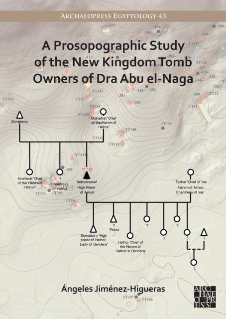
Prosopographic Study of the New Kingdom Tomb Owners of Dra Abu el-Naga
A Prosopographic Study of the New Kingdom Tomb Owners of Dra
Abu el-Naga contains the dating, kinship data and titles for
each tomb owner of a total of 54 tombs located in the southern area
and the beginning of the northern one of the Theban cemetery of Dra
Abu el-Naga during the New Kingdom. For each tomb owner information
related to chronology, ancestors, siblings, wives, children,
relatives, and career-titles, has been compiled, and kinship
diagrams have been created where possible. In order to obtain these
data, all the published and unpublished material related to the
tombs' owners in museums and archives all over the world has been
consulted. The book will prove of great assistance as a handbook or
catalogue for scholars and students intending to conduct research
on New Kingdom Dra Abu el-Naga or the surroundings areas of the
Theban necropolis as a base for the study of prosopography and
kinship relationships. A short introduction to the study explains
the utility of the data and the methodology used to gather the
information.
eBook

The fault systems that control the occurrences of iron ore deposits in northeastern Aswan, Egypt
The present study combines remote sensing data (Landsat-8 and ASTER) with structural analysis to identify the fault systems affecting the distribution of the ironstone beds in northeastern Aswan, Egypt. Sedimentary rocks, such as the Abu Aggag, Timsah, and Umm Brammily formations, characterize northeastern Aswan. The Abu Aggag Formation consists of kaolinitic conglomerate, conglomeratic sandstone, and mudstone. The upper Timsah Formation consists of ferruginous sandstones, oolitic ironstone, and mudstone. Fluvial sandstone forms the Umm Brammily Formation. The oolitic sandy ironstone (2–2.5 m thick) is rich in dark red oolitic hematite and goethite. The ironstone deposit ranges in composition from oolitic sandy ironstone to oolitic ironstone. The distribution of iron minerals is extremely consistent with the iron concentration grade indicated by the Landsat-8 and ASTER Brand Ratios. Five main fault sets to control the extension of the ironstone beds: NNE-SSW left-lateral strike-slip faults (set 1); ENE-WSW normal faults (set 2); NNW-SSE normal faults (set 3); NW–SE normal faults (set 4); and NE-SW normal faults (set 5). The subsequent displacement of Set 3 faults increased the depth of the ironstone bed, which raised the sedimentary overburden load and increased the cost of ironstone exploitation, as well as the absence of iron ore exploitation zones bordering the Nile River.
Journal Article