Catalogue Search | MBRL


Are you sure you want to remove the book from the shelf?

{{itemTitle}}
266
result(s) for
"Cartographers."
Sort by:


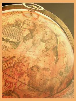
The Nile flowing from another World: They hypothetical southern continent on Johann Schoner's globe
This article examines a remarkable cartographic representation of the hypothetical southern continent, the belief in which goes back to classical antiquity. On Johann Schoner's 1515 globe this continent has a very unusual shape: it is a ring of land around the South Pole, with open water at the Pole, and it has a conspicuous hydrographic system, consisting of two large lakes, each surrounded by mountains, connected by a long river. The source of this unusual depiction turns out to be the theory, suggested by the Roman geographer Pomponius Mela, that the Nile floods in the summer because it has its source in the southern hemisphere, where the seasons are the opposite to those in the northern hemisphere, and flows north to its known location in Africa via a subterranean channel. Schoner adopted this theory and borrowed the depiction of a hypothetical western branch of the Nile from medieval mappaemundi and transferred it to his hypothetical southern continent, as a way of representing the Nile's presence there. His depiction, a remarkable example of the willingness of sixteenth-century cartographers to depict their speculations on maps, also appears on the anonymous Green Globe of ca. 1515, on Schoner's manuscript globe of 1520, and on a little-known world map by Francesco Maurolico that was printed in 1528.
Journal Article

Solving the puzzle under the sea : Marie Tharp maps the ocean floor
\"This illustrated biography shares the story of female scientist, Marie Tharp, a pioneering woman scientist and the first person to ever successfully map the ocean floor\"-- Provided by publisher.
Book


Scotland's Pariah
Scotland's Pariah is the first book to examine the remarkable life of John Pinkerton: antiquarian, poet, forger, cartographer, historian, serial adulterer, bigamist, and religious skeptic. A pugnacious and persistent man of letters who knew and was admired by literary masters such as Edward Gibbon, Horace Walpole, and William Godwin, Pinkerton's life was full of personal and professional misadventures.Patrick O'Flaherty's biography presents an engrossing account of Pinkerton's life and works from his early years in Scotland to his Parisian exile, covering his major editorial, antiquarian, and geographic works. Examining Pinkerton's involvement in the London literary scene, his conflicted relationship with the rise of Celtic nationalism, and his response to early literary romanticism, Scotland's Pariah is a shrewd and compassionate evaluation of an astonishing literary life.
eBook