Catalogue Search | MBRL


Are you sure you want to remove the book from the shelf?

{{itemTitle}}
28
result(s) for
"City planning -- Bangladesh -- Dhaka"
Sort by:

Alluvium : Dhaka, Bangladesh in the crossroads of water
Since 2007, architects Stephen Kieran and James Timberlake have directed a design-research laboratory on Dhaka for graduate students at the University of Pennsylvania School of Design. What began as a desire to help a city in need became an immersion in investigating its ebbs and flows, mapping its urban systems, and charting its development via annual visits. The result of this extended study is Alluvium: Dhaka, Bangladesh, in the Crossroads of Water, a cross-genre book that incorporates diverse media and layers of narrative and analysis to encourage new readings and perspectives. The book includes first-person narratives by architects and planners, documentary photographs, and maps and infographics that visually represent the intricate connections between people, water, land, and health in this delta megacity. The work proposes a new approach to understanding place that is interwoven with human interest--an intimate, collaborative, research-based model that holds relevance for both the developing and developed worlds.
Book

Toward great Dhaka : a new urban development paradigm eastward
A unique strategic opportunity beckons Bangladesh.Dhaka, the economic powerhouse of the country, stands on the cusp of a dramatic transformation that could make it much more prosperous and livable.Today, Dhaka is prone to flooding, congestion, and messiness, to a point that is clogging its growth.
eBook


Fragmented Dhaka : analysing everyday life with Henri Lefebvre's Theory of production of space
\"Bangladesh's capital city Dhaka is one of the world's fastest growing cities, passing from a population of one million to twelve million people in its extended area with three decades (1970-2000). This confronts its inhabitants , observers as well as planners with contradictions that ask for redefining our ways of living in and thinking about the city. In particular, Western conceptions of public space and urban societies are challenged by a symptomatic fragmentation. This empirical study observes the mega city's everyday spaces and situations directly and with a non-generalising approach. By means of ethnographic field research it describes the production of \"enriched\" or multi functional spaces through everyday life practices, recognising in the inhabitants' appropriation and adaptation processes a potential for sustainable mixed forms of urban development. For the first time, Henri Lefebvre's theory of production of space is applied with all of its implications to an empirical study. City and urbanity emerge then as the result of three continuously interacting and interdependent production processes: physical, mental , and social.\"--p. 4 of cover.
BOOK
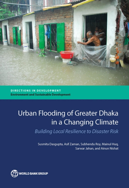
Urban flooding of greater Dhaka in a changing climate
Dhaka, the capital of Bangladesh and one of the world's rapidly growing megacities, is an urban hotspot for climate risks. Located in central Bangladesh on the lower reaches of the Ganges-Brahmaputra Delta, the city faces the recurring phenomena of urban flooding and waterlogging following intense rainfall nearly every year. As a low-elevation city with a tropical monsoon climate, Dhaka has a long history of river flooding as a natural hazard. Recent major floods have been worse in terms of depth and extent of inundation and duration, especially in fringe areas, where many of the city's poor reside. Rapid, unplanned urbanization and the gradual filling up of low-lying flood plains, rivers, canals, and other water bodies traditionally used to drain or retain water during rainfall have exacerbated the problem. A growing concern is that, in a changing climate, characterized by heavier and more erratic rainfall in the Ganges-Brahmaputra-Meghna (GBM) Basin during the monsoon season, the situation may worsen. The analysis in this book will help Bangladesh's policy makers take targeted steps to mitigate urban flooding in Dhaka and improve the city's resilience in the face of climate change and variability. Equipped with a host of investment options designed to address current flooding and further climate-proof urban infrastructure, local decision makers will be able to develop realistic, yet effective, strategies that prioritize interventions and sequence activities.
eBook

Spatial Analysis of Urbanization Patterns in Four Rapidly Growing South Asian Cities Using Sentinel-2 Data
The rapid and dominant urbanization in Asian cities has fueled concerns regarding the local and global efforts toward urban sustainability. Specifically, South Asian cities have been a topical issue concerning ecological and environmental threats due to their unplanned and haphazard urban development. However, comparative urbanization studies in South Asian cities remain uncommon. Therefore, in this study, we sought to comparatively examine the land use and land cover (LULC) dynamics and to detect the urbanization patterns of four rapidly developing South Asian lowland cities: Mumbai (India), Colombo (Sri Lanka), Karachi (Pakistan), and Dhaka (Bangladesh). Sentinel-2 (10 m) data and various geospatial approaches, including urban–rural gradient and grid-based methods, statistics, and urban landscape metric techniques, were used to facilitate the analysis. The study revealed that Mumbai, Karachi, and Dhaka had larger built-up landscapes compared to Colombo. Mumbai had the highest percentage of green spaces, followed by Colombo. Dhaka and Karachi had relatively small percentages of green spaces. Colombo and Dhaka had more croplands, which consistently increased along the urban–rural gradient compared to Mumbai and Karachi. Karachi showed that the only major land use was built-up, while most of the areas were left as open lands. On the other hand, Colombo’s urban setup was more fragmented than the other three cities. Mumbai and Karachi had larger patches of urban footprints compared to Colombo and Dhaka. Thus, this study provides vital information on the past land utilization priorities in the four cities, and comparatively proffers guidance on certain critical areas of focus for local, regional, and global future sustainable urban planning.
Journal Article

Designing a Blue-Green Infrastructure (BGI) Network: Toward Water-Sensitive Urban Growth Planning in Dhaka, Bangladesh
In a warming world, urban environmental stresses are exacerbated by population-increase-induced development of grey infrastructure that usually leaves minimal scope for blue (and green) elements and processes, potentially resulting in mismanagement of stormwater and flooding issues. This paper explores how urban growth planning in the megacity of Dhaka, Bangladesh can be guided by a blue-green infrastructure (BGI) network that combines blue, green, and grey elements together to provide a multifunctional urban form. We take a three-step approach: First, we analyze the existing spatial morphology to understand potential locations of development and challenges, as well as the types of solutions necessary for water management in different typologies of urban densities. Next, we analyze existing and potential blue and green network locations. Finally, we propose the structural framework for a BGI network at both macro and micro scales. The proposed network takes different forms at different scales and locations and offers different types of flood control and stormwater management options. These can provide directions on Dhaka’s future urban consolidation and expansion with a balance of man-made and natural elements and enable environmental, social, spatial, financial, and governance benefits. The paper concludes with some practical implications and challenges for implementing BGI in Dhaka.
Journal Article
Impact of Land Use and Land Cover Changes on Urban Ecosystem Service Value in Dhaka, Bangladesh
Urban ecosystem services provide a wide range of services to sustain life, social relation, health, etc., and address most of the challenges, including climate change and environmental pollution. While it is recognized that the urban ecosystem substantially contributes to human well-being in cities, there is less attention to consider the value of urban ecosystem service in urban planning and policymaking. This study analyzed the land use and land cover (LULC) dynamics of city of Dhaka over the past three decades (1990–2020) to evaluate the impact of LULC on ecosystem services value (ESV). The estimation of ESV in relation to LULC has been done using the globally used benefits transfer method (BTM). Findings of the study show that built-up area has increased by 188.35% from 1990 to 2020, with an average annual growth rate is about 6.28%The analysis of ESV shows that it has decreased by 59.55% (85 million USD) from 142.72 million USD in 1990 to 57.72 million USD in 2020 due to the development of the built-up area through conversion of agricultural land, waterbodies, and forest and vegetation land. This study also identified that waterbodies are the greatest contributor to ESV. The result on the elasticity of ESV in relation to LULC implies that about 1% transition in LULC would result in about 0.33% change in total ESV during the study period. We believe that the findings of this study would serve as a reference for the policy maker and urban planner to devise appropriate land use decision to ensure sustainable urban development of Dhaka.
Journal Article

Knowledge, Attitude, and Practices towards Dengue Fever among University Students of Dhaka City, Bangladesh
Dhaka has become the worst affected city in Bangladesh regarding dengue fever (DF). A large number of university students are residing in this city with a high DF risk. This cross-sectional study was conducted to assess the DF status and responses among these students through their Knowledge, Attitude, and Practices (KAP) survey. A total of 625 students participated in an online self-reported survey. Statistical analyses were performed to assess the status and KAP regarding DF. University students from the city perceived their living places as moderately safe (45.28%) against DF, whereas about 20% reported their DF infection history. Some of these students had exemplary DF knowledge (66.72%), attitude (89.28%), and practices (68.32%). However, many of them were also observed with a lack of knowledge about this disease’s infectious behavior, recognizing Aedes mosquito breeding sites, multiple infection cases, and the risk of DF viral infection during pregnancy. Fair correlations (p < 0.001) were determined in the KAP domain. Gender, residential unit, major, and dengue-relevant subjects were found to be significant predictors (p < 0.05) of KAP level in the univariate analysis. Major subject and residential units remained significant predictors of overall KAP level in further multiple analysis. This study revealed the urgency of infectious disease-related subjects and the relevant demonstration into the university curriculum. The study’s findings can assist the university, government and non-governmental organizations, and the health and social workers to prepare a comprehensive dengue response and preparedness plan.
Journal Article