Catalogue Search | MBRL


Are you sure you want to remove the book from the shelf?

{{itemTitle}}
363
result(s) for
"Stream conservation Case studies."
Sort by:

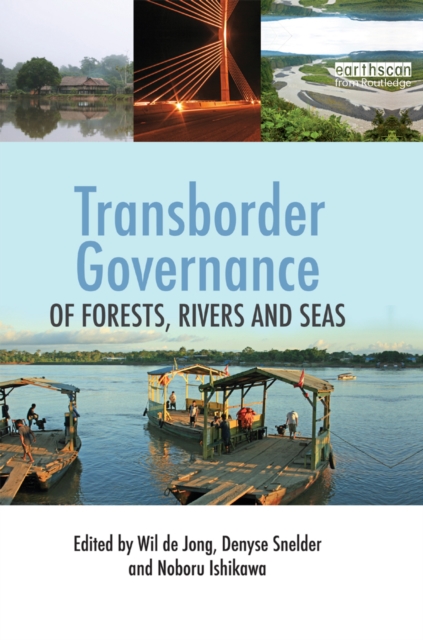
Transborder Governance of Forests, Rivers and Seas
Natural resources often stretch across borders that separate modern nation states. This can create conflict and limit opportunities for regulated consumption of their goods and services, but also provide opportunities for joint multinational efforts that exceed single country capabilities.
This book illustrates the diversity of transborder natural resources, the pressures that they experience or the opportunities that exist for multinational regulatory regimes, monitoring and enforcement. It presents ten case studies of transborder natural resources that are of interest to two or more neighboring countries, and that are subject to, or in need of bilateral or multinational coordinated management. The case studies include the exploitation of specific marine resources in international waters, rivers that travel through several countries and contiguous tropical forests across national borders, and where commodities, nature conservation or even territorial integrity are at stake. They are drawn from across the globe, including flood management in Western Europe, tropical forests in the Western Amazon, hydropower development in the Mekong region of South-east Asia, forest conservation in Central Africa and marine resource and fisheries exploitation in the waters of Japan, South-east Asia and Australia. Together the chapters provide a review of a wide range of transborder natural resource examples, and the diverse regulatory regimes that need to be devised to achieve successful management. An introductory chapter provides a conceptual and theoretical underpinning that can guide future research efforts on similar cases and a concluding chapter draws major conclusions and implications for related concepts and theories.
eBook

Restoring geomorphic integrity in urban streams via mechanistically-based storm water management: minimizing excess sediment transport capacity
Stream channel erosion, enlargement, and habitat degradation are ubiquitous in urban watersheds with conventional stormwater management that increase channel-eroding flows relative to undeveloped watersheds. Hydrologic-based restoration aims to discharge a more natural flow regime via stormwater management interventions. Whether such interventions facilitate geomorphic recovery depends, in part, on the degree to which they restrict discharges that would otherwise contribute to channel erosion. Erosion potential (E), the ratio of post-developed to predeveloped sediment transport capacity, provides a simplified, mechanistic framework to quantify the relative influence of stormwater interventions on the geomorphic effectiveness of the flow regime. This paper compiles ca. five years of data following stormwater-based interventions in three distinct settings in the United States and Australia to demonstrate how the E framework can elucidate the role of hydrologic restoration interventions in facilitating trajectories of geomorphic recovery (or lack thereof). In a previously developed watershed with unstable streams, substantial reductions in E in one stream coincided with a trajectory of geomorphic recovery, whereas the control stream without E-reducing interventions exhibited continued instability. Furthermore, a stream downstream of a greenfield development that optimized their stormwater control measures to match the sediment transport capacity of the predeveloped regime (E = 1) was able to maintain a recovery trajectory in a legacy-impacted setting that is otherwise highly susceptible to hydromodification. Streambed material size, channel evolution stage, and the hydrogeomorphic setting also likely affect the level of E reduction necessary to promote geomorphic recovery, with coarser-grained and over-widened streams potentially needing less reduction than finer-grained and more entrenched channels. Although available space and funding will limit the ability to fully reduce E in previously developed watersheds, these case studies underscore the value of using stormwater control measures to maximize reductions in E if geomorphic stability is a goal of stormwater interventions.
Journal Article

Identifying climate‐change refugia for species management and conservation in the Pacific Northwest
The impacts of climate change are already affecting many species and habitats, presenting challenges for species management and conservation. Protecting climate refugia—areas buffered from climate shifts where species can persist despite broader changes—has been proposed as a tool for managing species under climate change. Although many studies have mapped climate refugia, few have identified them for specific species at scales relevant to local management. To address this gap, we identified potential climate refugia for seven species of concern in the Pacific Northwestern United States: Cascade torrent salamander (Rhyacotriton cascadae), Rocky Mountain tailed frog (Ascaphus montanus), coastal tailed frog (Ascaphus truei), Greater Sage‐grouse (Centrocercus urophasianus), pygmy rabbit (Brachylagus idahoensis), fisher (Pekania pennanti), and White‐headed Woodpecker (Leuconotopicus albolarvatus). Collaborating with managers and species experts, we identified key factors influencing refugia locations and integrated multiple spatial data layers to map potential refugia for each species. For the three aquatic species, potential refugia included streams with cooler current and projected future temperatures, sustained future streamflow, and watersheds with greater canopy cover and cool valley bottoms. For the terrestrial species, refugia were linked to fire risk, ecological transformations, range shifts, soil moisture, and topographic complexity. Identifying potential refugia can guide conservation by prioritizing areas for protection and management. Sites with high‐quality habitat but limited refugia potential could become conservation priorities if habitat quality declines, whereas lower‐quality sites with greater refugia potential may warrant further protection. Areas with poor refugia potential may benefit from management actions to enhance resilience. Although expanding this approach to all species of concern would be valuable, it remains resource intensive. We conclude with recommendations for improving the efficiency of refugia identification in future studies.
Journal Article

Active Adaptive Management for Conservation
Active adaptive management balances the requirements of management with the need to learn about the system being managed, which leads to better decisions. It is difficult to judge the benefit of management actions that accelerate information gain, relative to the benefit of making the best management decision given what is known at the time. We present a first step in developing methods to optimize management decisions that incorporate both uncertainty and learning via adaptive management. We assumed a manager can allocate effort to discrete units (e.g., areas for revegetation or animals for reintroduction), the outcome can be measured as success or failure (e.g., the revegetation in an area is successful or the animal survives and breeds), and the manager has two possible management options from which to choose. We further assumed that there is an annual budget that may be allocated to one or both of the two options and that the manager must decide on the allocation. We used Bayesian updating of the probability of success of the two options and stochastic dynamic programming to determine the optimal strategy over a specified number of years. The costs, level of certainty about the success of the two options, and the timeframe of management all influenced the optimal allocation of the annual budget. In addition, the choice of management objective had a large influence on the optimal decision. In a case study of Merri Creek, Melbourne, Australia, we applied the approach to determining revegetation strategies. Our approach can be used to determine how best to manage ecological systems in the face of uncertainty.
Journal Article

Managing water quality of a river using an integrated geographically weighted regression technique with fuzzy decision-making model
In the recent times, water quality of most of the rivers in India has been steadily degrading due to increasing numbers of point and non-point sources of pollution. The tremendous increase in population, rapid urbanization, change in irrigation patterns, and unplanned growth of industries without proper enforcement of environmental standards are some of the major causes for poor quality of river water. In addition, unpredictable and scanty rainfall is resulting in uncertain natural stream flow which further leads to uncertainty in assessing and predicting the quality of river water. This paper deals with the assessment of the overall status of water quality of a river by developing a fuzzy-based water quality evaluation system. The quality of water needed for different beneficial uses is based on the value of various parameters. Since the quality attributes of the parameters are fuzzy in nature, they have been described by the linguistic variables. The water quality index of each specific site is then calculated by aggregating the attributes with respect to their degree of importance, which is also expressed in the form of linguistic terms. Finally, a case study of the river Yamuna has been carried out to evaluate the fuzzy comprehensive water quality index (FCWQI). In this study, the FCWQI has been determined only for the use of water for drinking purposes though this model can be applied for other uses as well. The FCWQI developed herein is based on an integrated approach, which clearly describes the overall state of the water quality by a single rational number. Spatial and parametric sensitivity of the FCWQI model of the river basin is also determined using GIS-based geographically weighted regression technique. The methodology suggests a novel way of introducing parametric sensitivity in defining water quality indices used for surface water quality assessment.
Journal Article

Developing state and transition models of floodplain vegetation dynamics as a tool for conservation decision-making: a case study of the Macquarie Marshes Ramsar wetland
1. Floodplain vegetation states (communities) exhibit spatiotemporal dynamics in vegetation structure and composition, which reflect unique hydrological and connectivity patterns. Shifts in inundation regimes can drive succession and establish new stable states, determined by the magnitude and duration of the hydrological perturbation. 2. We aimed to develop a modelling approach that is able to capture ecosystem dynamics, identify and quantify the main drivers of change, and provide a tool for conservation decision-making. We developed state and transition models for floodplain vegetation states based on surveys in 1991 and 2008 in the Macquarie Marshes (Australia), a Ramsar wetland of international importance. We used a Bayesian logistic regression approach to model state and transitions between vegetation states and investigated how flood frequency, distance to stream and fire frequency were associated with vegetation dynamics during this period. 3. During 1991-2008, significant transitions have occurred towards drier states. Semi-permanent wetland vegetation had the lowest persistence probability (ppsis = 0·456) and a significant threshold response of transitioning to terrestrial vegetation (ptran = 0·505). Transition to drier states was driven by lower inundation probabilities followed by increased fire probability, and distance to nearest stream. 4. Using developed models, we predicted persistence probabilities of vegetation states under an unregulated (i.e. no dams or diversions) and regulated water availability system. Under a regulated system, semi-permanent wetland vegetation had an average persistence of ppsis = 0.67 and 0·08 in the northern and southern sections of the nature reserve, respectively. Under an unregulated system, the predicted persistence of semi-permanent wetland vegetation was considerably higher: ppsis = 0·87 and 0·38, respectively. 5. Synthesis and applications. Developing quantitative models of state transitions significantly improved our understanding of ecosystem dynamics, identifying sensitive indicators for monitoring and thus supporting conservation decision-making. This helps managers understand potential trajectories of change in ecosystems in response to management options. For example, increasing environmental flows in the Macquarie Marshes is predicted to shift the community towards more of a wetland than the terrestrial state, resulting from river regulation. State and transition models identified how key ecological assets respond to drivers of change, particularly where these can be managed. This is critical for ensuring that all ecosystem components are managed and that these do not shift into undesirable states.
Journal Article

Simplifying complexity: the novel degradation index for urban stream landscapes—case of Tekirdag
This study aims to examine the degradation process of urban stream landscapes in Tekirdağ by utilizing a newly developed degradation index (DI) that effectively defines degradation. The DI considers the vital factors that affect urban stream landscapes, making it possible to determine the level of degradation and resulting environmental quality. This index aims to provide valuable insight into the degradation of urban stream landscapes with a minimal amount of independent variables and training samples. The key enhancements of the DI include its clear computation of degradation value, ease of replication, and overall objectivity. The results indicate that the most substantial change has been observed on impermeable surfaces between 2000 and 2020, resulting in a 5.18% increase in impervious surfaces. Furthermore, there has been a decrease by 4.67% in agricultural lands, highlighting a pronounced shift towards impervious surfaces. The total percentage of areas categorized as high and very high degradation categories increased by 1.54% over the study period. Additionally, the area classified as high degradation expanded from 135.91 to 375.42 hectares between 2000 and 2020. Notably, there was no land classified as very high degradation in 2000, whereas in 2020, it reached 38.15 hectares. The DI has been proven to provide better representational information on how human activity affects ecosystems compared to both the Human Influence Index and the Human Footprint Index which has been used for this purpose. As a valuable tool for urban planning strategies, the DI can provide decision-makers with a more precise depiction of degradation, aiding in the preservation of sustainable urban stream landscapes, particularly in rapidly urbanizing areas.
Journal Article
Expanding catchment-scale hydrologic restoration in suburban watersheds via stream mitigation crediting—A Northern Kentucky (USA) case study
The need for hydrologic restoration is well established in stream ecosystems across the world; however, available funding for catchment-scale restoration typically falls far short of what is required to produce in-stream results. Hydrologic restoration can be particularly important for improving stream integrity in urban watersheds, but implementation can be challenging due to high property values and limited space for retroactive stormwater control measures. This Northern Kentucky (USA) case study summarizes how stormwater mitigation interventions could be, and have already been, used to credit stream mitigation projects via conventional US Army Corps of Engineers crediting protocols. Hydrologic restoration can generate stream mitigation credits by directly improving the flow class and/or by indirectly improving the habitat quality. For example, a stormwater intervention could create a shift from an ephemeral to intermittent flow class, while at the same time facilitating greater substrate stability, lower embeddedness, and other geomorphic improvements, that subsequently improve the categorical habitat rating. The ecological lift of such hydrologic interventions could be further expanded via concurrent in-stream mitigation measures such as re-establishing a jurisdictional stream in place of a drainage ditch or installing habitat structures such as toe wood and log steps, among other activities. Such process-based hydrologic restoration is consistent with the goals of the Clean Water Act and has the potential to be more beneficial to greater portions of stream networks and greater numbers of stakeholders than conventional habitat restoration alone.
Journal Article

Agricultural impacts on streams near Nitrate Vulnerable Zones: a case study in the Ebro basin, Northern Spain
Agricultural intensification during the last century has caused river degradation across Europe. From the wide range of stressors derived from agricultural activities that impact rivers, diffuse agricultural pollution has received most of the attention from managers and scientists. The aim of this study was to determine the main stressors exerted by intensive agriculture on streams around Nitrate Vulnerable Zones (NVZs), which are areas of land that drain into waters polluted by nitrates according to the European Nitrate Directive (91/676/EEC). The study area was located in the NW of La Rioja (Northern Spain), which has some of the highest nitrate concentrations within the Ebro basin. The relationships between 40 environmental variables and the taxonomic and functional characteristics of the macroinvertebrate assemblages (which are useful indicators of water quality) were analyzed in 11 stream reaches differentially affected by upstream agricultural activity. The streams affected by a greater percentage of agricultural land cover in the surrounding catchment had significantly higher nitrate concentrations than the remaining sites. However, hydromorphological alteration (i.e. channel simplification, riparian forest and habitat degradation), which is closely linked to agricultural practices, was the main factor affecting macroinvertebrate assemblages. We suggest that 'good agricultural practices' should be implemented in streams affected by NVZs to reverse stream degradation, in concordance with the European Water Framework Directive (WFD).
Journal Article